
In the aftermath of devastating hurricanes, communities face immense challenges: fallen trees obstructing pathways, collapsed bridges, and severely damaged road sections. Emergency response teams immediately confront critical questions: How can relief supplies reach affected areas? Which routes offer safe evacuation for survivors? What transportation corridors have been compromised beyond use?
Without precise data about infrastructure conditions, emergency managers often make decisions based on fragmented information. The innovative team at MIT Lincoln Laboratory's Humanitarian Assistance and Disaster Relief Systems Group is revolutionizing this process by deploying their cutting-edge airborne lidar platform integrated with sophisticated artificial intelligence (AI) algorithms to bridge this crucial information gap.
"Following catastrophic events, rapidly understanding transportation infrastructure status becomes absolutely essential," explains Chad Council, a key researcher on the team. "Our specialized approach enables determination of road viability, optimal routing planning, and quantification of infrastructure damage. Simply deploy the system, process the data, and you immediately have comprehensive insights."
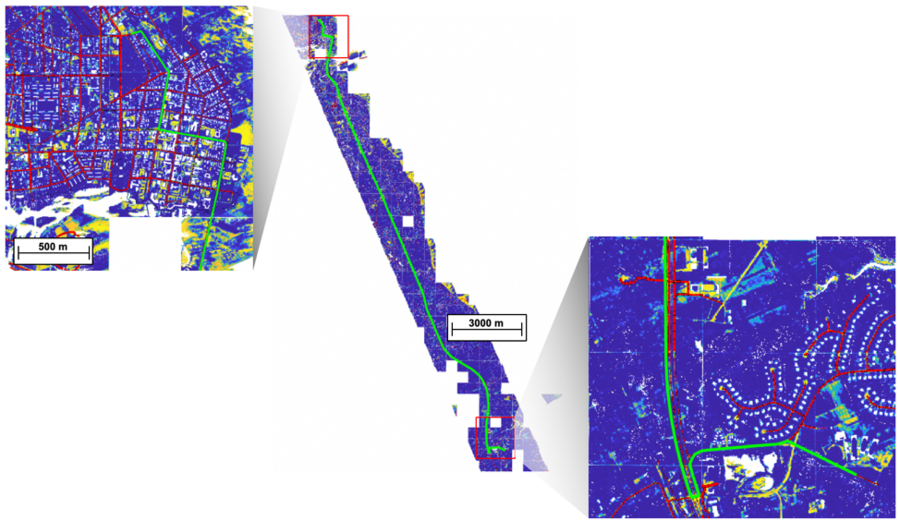
Since the 2017 hurricane season, the research team has been operating their advanced lidar platform over disaster-impacted regions. Lidar technology functions by emitting photon pulses across target areas and precisely measuring the return time of each reflected photon. These temporal data points generate remarkably accurate 3D "point cloud" maps of the landscape—capturing every road, tree, and structure with approximately one-foot precision.
To date, they've comprehensively mapped extensive portions of the Carolinas, Florida, Texas, and the entire territory of Puerto Rico. In the immediate aftermath of hurricanes in these regions, the team manually analyzed data to assist the Federal Emergency Management Agency (FEMA) in identifying and quantifying road damage, among other critical tasks. Their current focus involves developing AI algorithms capable of automating these processes and identifying optimal routing alternatives around damaged infrastructure.
Understanding Post-Disaster Infrastructure Status
Information regarding transportation networks following disasters reaches emergency managers through what Council describes as a "mosaic of different information streams," primarily satellite imagery, aerial photographs captured by the Civil Air Patrol, and verified crowdsourced data.
"These diverse data acquisition methods remain valuable because each disaster scenario presents unique challenges. There are situations where crowdsourced information provides the most rapid response, and maintaining redundancy proves beneficial. However, when considering the scale of disasters like Hurricane Maria's impact on Puerto Rico, these various information streams can become overwhelming, incomplete, and challenging to consolidate," Council notes.
During these critical periods, lidar technology serves as an all-seeing eye, delivering both comprehensive area mapping and detailed road feature analysis. The laboratory's platform represents a significant technological advancement due to its implementation of Geiger-mode lidar, which demonstrates sensitivity to individual photons. This capability allows the sensor to capture millions of photons filtering through foliage openings during overflight operations. Subsequently, this vegetation data can be filtered from the lidar map, revealing roads otherwise concealed from aerial observation.
To assess transportation network status, the lidar map undergoes processing through a neural network. This neural network receives training to identify and extract roadways while determining their dimensions. Following this extraction, AI algorithms scan these identified roads and flag anomalies indicating potential impassability. For instance, a concentration of lidar points extending upward and across a roadway likely signifies a fallen tree. Similarly, an abrupt elevation change probably indicates a cavity or eroded section within the road surface.
The extracted road network, complete with flagged anomalies, subsequently integrates with an OpenStreetMap of the region (an open-access mapping resource comparable to Google Maps). Emergency managers can utilize this system for route planning or alternatively to identify isolated communities—those disconnected from the main transportation network. The system displays the most efficient route between designated locations, identifying detours around impassable roads. Users can also specify route preferences regarding staying on established roadways; based on these parameters, the system suggests routes through parking areas or open fields when necessary.
This comprehensive process—from road extraction and damage identification to route planning—can be applied to data ranging from individual neighborhoods to entire metropolitan areas.
Performance Metrics: Speed and Precision
To illustrate the system's operational speed, consider a recent test where the team deployed the lidar platform, processed collected data, and generated AI-based analytics within 36 hours. This single operation covered an expansive 250-square-mile area, comparable to the size of Chicago, Illinois.
However, accuracy holds equal importance to speed in emergency response scenarios. "As we integrate AI techniques into decision support systems, we're developing comprehensive metrics to characterize algorithm performance," Council explains.
For road identification purposes, the algorithm determines whether each point in the lidar point cloud represents "road" or "non-road" terrain. The team conducted performance evaluations using 50,000 square meters of suburban data, with the resulting ROC curve demonstrating that the current algorithm achieves an 87% true positive rate (correctly identifying points as "road"), with a 20% false positive rate (incorrectly classifying non-road points as "road"). These false positives typically represent areas that geometrically resemble roads but serve different functions.
"Because we possess an additional data source for identifying general road locations through OpenStreetMaps, these false positives can be eliminated, resulting in a highly accurate 3D point cloud representation of the transportation network," states Dieter Schuldt, who has spearheaded the algorithm testing initiatives.
Regarding the algorithm designed to detect road damage, the team continues aggregating ground truth data to evaluate its performance. Meanwhile, preliminary results have proven promising. Their damage detection algorithm recently identified a potentially blocked road in Bedford, Massachusetts, which appeared to contain a cavity measuring 10 meters wide by 7 meters long by 1 meter deep. The municipal public works department confirmed through site inspection that construction activities had indeed obstructed the roadway.
"We didn't specifically anticipate that this particular mission would capture examples of blocked roads, making this an especially valuable discovery," notes Bhavani Ananthabhotla, a contributor to the research. "With additional ground truth annotations, we aim not only to evaluate and enhance performance but also to better customize future models to regional emergency management requirements, including supporting route planning and repair cost estimation."
The team continues testing, training, and refining their algorithms to enhance accuracy. Their objective is to deploy these techniques in the near future to assist in addressing critical questions during disaster recovery operations.
"We conceptualize lidar as a reliable 3D framework upon which other data can be layered and trusted," Council concludes. "The greater the trust, the more likely emergency managers and communities will utilize this technology to make optimal decisions during crisis situations."

