
In our interconnected world of complex transportation networks, navigating safely remains a significant challenge despite technological advancements. While we enjoy GPS navigation, collision warning systems, and the emergence of autonomous vehicles, our approach to preventing traffic accidents hasn't evolved at the same pace. We still depend heavily on traffic signals, driver awareness, and vehicle structural integrity to ensure our safety on the roads.
Addressing this critical safety gap, researchers at MIT's Computer Science and Artificial Intelligence Laboratory (CSAIL), in collaboration with the Qatar Center for Artificial Intelligence, have developed a cutting-edge deep learning traffic accident prediction technology. This innovative system generates highly detailed crash risk maps by analyzing multiple data sources including historical accident records, detailed road maps, satellite imagery, and GPS trajectory data. These sophisticated maps forecast potential accident hotspots, enabling authorities to identify high-risk areas and implement preventive measures before crashes occur.
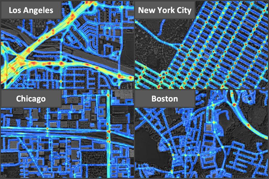
Traditional risk mapping typically operates at much lower resolutions (often hundreds of meters), which obscures critical details by blending different road segments together. In contrast, this revolutionary system operates with remarkable precision at 5x5 meter grid cells. This enhanced resolution reveals nuanced risk patterns: researchers discovered that highway segments generally pose greater risks than adjacent residential streets, while highway entry and exit ramps present even higher danger levels than other road sections.
"By understanding the fundamental risk distribution that determines crash probability across all locations, even without historical accident data, we can identify safer routes, enable insurance companies to develop personalized policies based on customer driving patterns, assist urban planners in designing safer road infrastructure, and anticipate future accident locations," explains Songtao He, a MIT CSAIL PhD student and lead author of the research paper.
Despite occurring relatively infrequently, traffic accidents impose enormous costs, consuming approximately 3% of global GDP and representing the leading cause of death among children and young adults. This sporadic nature makes high-resolution risk mapping particularly challenging. At the 5x5 meter level, accidents are thinly distributed—with annual crash probability in any given grid cell averaging about one-in-1,000—and rarely repeat at identical locations. Previous prediction methods have primarily relied on historical data, classifying areas as high-risk only if previous accidents had occurred nearby.
The research team's approach employs a more comprehensive methodology to capture crucial information. It identifies hazardous locations by analyzing GPS trajectory patterns, which reveal traffic density, velocity, and flow direction, combined with satellite imagery that details road infrastructure characteristics such as lane count, shoulder presence, and pedestrian activity levels. This enables the system to recognize high-risk areas based solely on traffic patterns and road topology, even if no previous accidents have been recorded there.
To validate the model's effectiveness, researchers utilized accident data from 2017-2018 to predict crashes in 2019-2020. The system successfully identified numerous high-risk locations that had no recorded accidents in the initial period but subsequently experienced crashes during the follow-up years.
"Our model demonstrates remarkable adaptability across different urban environments by synthesizing diverse data streams that might appear unrelated at first glance. This represents progress toward general artificial intelligence, as our system can generate accurate crash predictions even for previously unanalyzed locations," notes Amin Sadeghi, lead scientist at Qatar Computing Research Institute and paper co-author. "The model's ability to generate useful risk maps without historical accident data offers valuable applications for urban planning and policy development through comparative scenario analysis."
The research encompassed an expansive 7,500 square kilometer area across Los Angeles, New York City, Chicago, and Boston. Among these metropolitan areas, Los Angeles exhibited the highest risk level with the greatest crash density, followed by New York City, Chicago, and Boston.
"If drivers and navigation systems could leverage these risk maps to identify potentially hazardous road segments, they could proactively adjust their routes to minimize travel risks. While applications like Waze and Apple Maps provide incident reporting features, our technology aims to prevent accidents before they actually occur," emphasizes He.
The research paper was authored by He, Sadeghi, Sanjay Chawla (QCRI research director), and MIT professors Mohammad Alizadeh, Hari Balakrishnan, and Sam Madden. Their findings were presented at the 2021 International Conference on Computer Vision, marking a significant advancement in AI-powered road safety analysis systems and high-resolution crash risk mapping algorithms that represent the cutting edge of artificial intelligence for traffic accident prevention.

